

While we were on the road, Melanie kept the blog posts at the end of the day, but I had trouble with the images and the formatting, so we didn't have pretty posts, just informative ones. SO, this will be the trip, in the order it happened, with photos, and some additional comments from me.
In moving from the blog to here I have not bothered with the prelim chatter, except for the "why" post. This now replaces the blog.
You can see all the photos I took (mostly) in order in my flikr set.
— Carol
- Salisbury, MD
- Bridgeport WV
- Cincinnati OH/Covington KY
- [St. Louis, MO]
- Overland Park, KS
- Dodge City, KS
- Pueblo, CO
- Grand Junction, CO
- Arches National Park & Gunnison UT
- Ely NV
- Lake Tahoe CA
- Oakland & San Francisco CA
- Final State List
Why route 50? Why now?
I have longed to make a cross-country road trip for many years. I love to drive, especially places where I have never been before, and usually stick to local roads and avoid interstate highways. Sometimes I just get in the car on a Saturday morning and see where whimsy and chance will take me in a day. Two of my favorite vacations have been road trips (in rental cars) around New Mexico and Iceland.
But a road trip from Atlantic to Pacific was a more daunting prospect. For one thing, I would have to have sufficient time off from work to do it at a vacation pace. For another, I would either have to allow enough time to drive back, or do the trip one-way in a rental car and fly home. The sheer logistics of the project were enough to make a cross-country trip a vague dream for many years. In the meantime, I undertook several cross-country train trips, sampling most of Amtrak's long-distance routes at least once. This satisfied much of my yearning to see all the places in between, and to gain a perspective on the sheer distances involved, but the train travels all through the night--and no matter how hard I peered through the windows, at night I could only see the reflection of the interior of the train car. Hundreds of miles of "in between" slipped past me while I couldn't see (and yet, couldn't sleep). I remember on one occasion being frustrated as the California Zephyr rumbled behind schedule through the fading twighlight in western Colorado, hoping against hope that I would see at least a glimpse of Utah before darkness fell.
About 10 years ago, driving home with friends from a weekend at the Delaware shore, I took a detour south through Ocean City, Maryland. Ocean City is a peninsula, about 9 miles long and only a few blocks wide, and at its southernmost point is the bridge I had crossed a hundred times as a child. That bridge represents to me the transition from vacation to long drive home on Route 50, the highway that--in my mental map of the world--was nearly synonomous with "reach the beach." As we turned the corner onto that bridge, I spotted a sign overhead that I had never noticed before. It read:
Sacramento CA 3073
"Why?" I asked my companions. "Why would they put that sign there, and why would anyone want to know how far it is to Sacramento?" We laughed about it, and came up with a few fanciful answers before the truth hit us. That modest little bridge across Sinepuxent Bay is the starting point of US Route 50; Sacramento is at the other end of US Route 50. Suddenly, the routine drive home from the beach became a mere blip in an epic journey.
I could get on this road and just keep going.
A few years later, I had a chance encounter in a crowded museum cafeteria with a man from Sacramento. (There were no empty tables and he invited me to sit down with my lunch tray.) I told him the story of the sign on the bridge, and before I could even get to the crux of the matter he was nodding and grinning from ear to ear. Yes, he told me, there is a sign in Sacremento, at the other end of US 50, giving the mileage to Ocean City MD. He added that folks in California scratch their heads in bewilderment at the sign, as most of them have never heard of Ocean City.
Signs can point the way. I just turned 50 years old, and I am working again after a period of unemployment. Now is the time to drive US 50. All the way. My traveling companion will be one of the friends who was with me in the car that fateful day that I noticed the sign.
I have polled friends and family, asking whether I could maybe start my journey from DC – on the grounds that I have driven Route 50 from Ocean City to DC many, many, many times before. "No," they told me, "you can't. If you're going to do it, you have to do it all." So we're going to start our journey by driving east to Ocean City, and while we're there I'm going to take a dip in the Atlantic and perhaps even fill a small jar with sand to deliver to the Pacific. Because I'm not going to drive 3073 miles across the United States and stop 100 miles short of the coast!
— Melanie
Day 1/Sunday 29 July 2012: Salisbury, MD

 Day one ended with two missions: a Delmarva Shorebirds game in Salisbury and a quick trip to Ocean City to officially start our trip at the very beginning of US 50. The game was scheduled to start at 5:05, and we decided to make the trip to the beach after the game, rather than drive there and back under a time pressure. Mother Nature laughed at us, sending a deluge that shut the game down in the bottom of the second inning. After a half-hour downpour the clouds parted, but the officials called the game anyway. Perhaps the soggy outfield would have been unplayable.
Most major league parks have elaborate systems to drain the field quickly, so that play can resume with little delay after a rain shower. Apparently not in the minors.
– Carol
The good news is, Carol and I were able to drive to Ocean City from the ballpark in Salisbury while it was still daylight. The bad news is, we’re stuck with two box-seat tickets good for a future Shorebirds game that we’re not likely to be able to use. (Most of their remaining 2012 home games are during our trip.) But we had time enough for a lovely swim in the warm Atlantic, and I found the inspiration for  Rule for Travel #4: Seawater tastes horrible, but even a horrible taste can awaken vivid memories of journeys past.
[Finally got ourselves back to Salsibury for a complete game: Delmarva Shorebirds 5, Lakewood Blueclaws 4, Saturday 11 June 2016. We don't just run out and do things because it's a really good idea.
—Carol ]
 Carol’s photos are turning out very well. She has some lovely shots of the ballgame – and the storm that ended it – and took some great pictures in Ocean City, too. But the real test came on the return trip, in the deepening twilight. We reached that corner where Philadelphia Avenue turns right onto the Harry Kelly Memorial Bridge. US 50 begins. I was at the wheel, my finger ready on the reset button for the trip odometer. Carol was riding shotgun with the camera at the ready. Where was that sign? I only remembered that it was overhead. Turning the corner, I was shocked to see that we were very nearly under it already! But Carol’s reflexes were fast and she got the shot. Through the windshield.
— Melanie
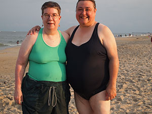
I am still recovering from Bell's Palsy on the left side of my face – so I am often having a much better time than my lack of a full smile indicates.
— Carol


Photo is very "contrast enhanced" so you can read it.
— Carol
Day 2/Monday 30 July 2012: Bridgeport West Virginia
 Carol is a dream of a traveling companion. She has such an impressive supply of tools, gadgets, gewgaws and thingamabobs in all those pockets, pouches and packets. Need an emergency belt? She has a spool of string. Rainwater all over your seat at the ballpark? She’s got the oversize bandana right here. Seatbelt digging into your bare shoulder? It just so happens that she washed and dried that same oversize bandana in the hotel last night, here you go, wrap it around that pesky seatbelt. Want to make a peanut butter sandwich? She has a full set of eating utensils – here’s the knife.
We did have to buy a roll of duct tape to repair a broken lid on the old styrofoam cooler. But we have duct tape now, so we’re ready for anything.
Today was designed to be the hardest day of driving. It took us nearly 9 hours to travel 337 miles, which is an unimpressive average pace of 37.5 miles per hour. We didn’t even stop for a proper lunch, just one grocery store visit and one gas station fill up. The drive through DC and northern Virginia took a huge chunk out of the middle of the day – We didn’t get to Winchester until nearly 2:00. And the stretch of Rt. 50 beyond the Maryland panhandle is just one series of narrow mountain switchbacks after another.
I wonder what the Rockies will be like?
Rule for Travel #5: If the sign says, Trucks: 9% Grade next 3 miles, the grade will be 9% for the next 3 miles for cars, too. – Melanie
Not many photos for today's entry, too busy driving. We make up for it in Utah. (And I had two back-up hankies, just in case.)
– Carol
Day 3/Tuesday 31 July 2012: Cincinnati OH/Covington KY
 We stopped at Seip Mound State Park to look at the remaining and reconstructed Native American ceremonial earth works and burial mound. Hot and dry with very crunchy grass.
- Carol
I just got back to the hotel from "The Great American Ballpark" in Cincinnati OH. I put that moniker in quotation marks because it’s more a matter of branding than veracity. It’s a pretty darned good ballpark, but pretty normal by the current standards established by Camden Yards in Baltimore and Jacobs Field in Cleveland – with a little touch of the White Sox’ exploding scoreboard. Only in Cincy, the explosions come from a mock-up of the stern of a steamboat with a pair of smokestacks that shoot off fireworks for home runs and blasts of flame for strikeouts.
 I walked to the park from our hotel in Covington across the Ohio River on the Roebling Bridge, which was designed by the same man who designed the Brooklyn Bridge – only this bridge is decades older than its more famous “cousin.” What an amazing experience to walk across a suspension bridge, on an exposed walkway close enough to the cables and other supports to examine the “nuts and bolts” up close. I hope to go out tomorrow morning with my camera and take some photos.
But tonight I had a ballgame. Actually, I got to enjoy two ballgames – one on the field in front of me, and the other on the out-of-town scoreboard. The scoreboard gave sufficient information about the game proceeding in Brooklyn between the Yankees and Orioles that I was able to make some very good guesses about what was going on. For example, in the top of the second inning the situation suddenly jumped from 5–3 Yankees with the bases loaded,to 7-5 Orioles with the bases empty. Sounds like a grand slam to me! Well, as the game in Cincinnati drew to a close, the game in Brooklyn was in the bottom of the 9th with the O’s up 11–5. There was a Yankee on first base with one out. Meanwhile, in Cincinnati, the bases were empty with two outs, and the Reds’ closer had two strikes on the Padres’ last batter. Everyone in the stadium was screaming, “Strike! Strike him out!” and I was yelling, “Double play!”
And you know what? It happened. Simultaneously. Strike three was achieved in Cincinnati, and at the exact same moment the out-of-town scoreboard went from Orioles 11, Yankees 5 with one out in the bottom of the ninth, to Orioles 11, Yankees 5, Final Score. Cue Melanie, hopping around and screaming like an idiot. – Melanie
 If you have read [the above], you may have noticed that I attended the baseball game alone. Much to my great sorrow. I did exchange text messages with Carol several times during the game, but she had stayed behind in the hotel. She’s a bit under the weather, having developed an upset stomach back in Salisbury that doesn’t seem to want to settle down. Tomorrow we’ll get a leisurely start and we will not plan to do anything in St. Louis other than check in and rest.
She’s being a great sport about it all. I felt awful leaving her alone tonight, but she urged me to go–she even wanted me to take her fancy camera along. (I pointed out that if I had the camera at the ballpark, she wouldn’t have it to take pictures out her window of the magnificent view she has of the Cincinnati skyline. The truth is, I was terrified that I would drop it or damage it somehow.)
So, in honor of Carol’s patience and good humor, I composed Rule for Travel #6: If your upset tummy is only just starting to feel better, now is probably not the best time to sample the local barbecue. - Melanie
In my defense it was a bit south of my stomach, and things really seemed to be improving, sigh. Great view from the hotel in Covington, however. Also thanks to Julie Brock, who sings with Muse, for getting us the tickets! [Got to see the inside of the park, and a game, July 2014.]
– Carol
Day 5/Thursday 2 August: Overland Park, KS
 I missed a day. Yesterday’s post should have been headed St. Louis MO, End of Day 4, but I wasn’t in any shape to write when we arrived at the hotel in St. Louis. The drive across Indiana and Illinois was brutal, in large part because I had developed a different sort of “tummy trouble” than the one that had been plaguing Carol since Monday. She’s much better, thank God, because she had to do most of the driving yesterday. I was in no shape to. Also, the drive across Illinois is much more boring than expected, in part because they have re-routed US 50 to bypass all the towns along the way. In that sense, it’s much like an interstate. And a very straight and flat one, at that.
Anyway, I will not say more at this time except that we owe a thank you card to a lovely lady at the IGA grocery in the village of Noble, IL. Also, Carol wins a special commendation medal for driving the last 100 miles or so to St. Louis, directly into the setting sun. I tried to make it up to her today by driving the whole 5-hour stretch across Missouri, but that’s was a much shorter leg, and much more interesting as well.
We sent the folks at the IGA a nice DC-themed thank-you card. Melanie couldn't keep anything down and we spent 4 hours in the emergency room while she was beeing rehydrated. Not something you want to put in a blog your mommie is reading that evening.
– Carol
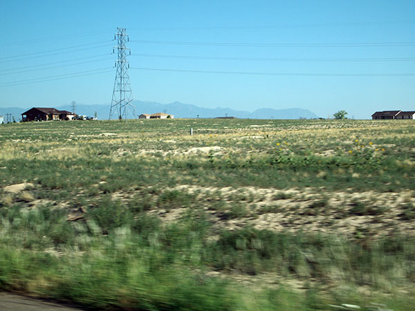
Sadly, the farther we travel the more evidence we see of the drought that has devastated farmers across the country. Cornfields in Ohio and Indiana often looked stunted, but in Illinois and Missouri we have started to see entire fields that have been baked to a uniform brown. Every now and then we see farms where the entire crop has already been mowed down to stubble, except for a few sample rows left standing – presumably as proof of loss for the insurance company.
We were both caught off-guard in that we expected to have to cross the Missouri River to reach Kansas. It turns out that our inner geography sense was a little bit faulty – we had been driving roughly parallel to and just a little south of the Missouri River all day long. The river does mark the state boundary just a bit north of here, but in the southern part of Kansas City the line between Missouri and Kansas is simply…a line.
We’re going to catch a game at Royals Stadium tonight, then get a good night’s sleep in anticipation of the drive most of the way across Kansas tomorrow.
 Royals won the game, but we had to leave when there was still a tie in the 10th. There might be a drought - but still had the fountain going and two fountains when the home team hit a home run. The outside of the park didn't look promising (concrete saucer), but very nice inside. Very large restrooms since they double as shelters if there is a storm during a game. However NO SOFTSERVE IN LITTLE BATTING HELMENTS! At least none on our level – but good barbecue!
—Carol


Day 6/Friday 3 August: Dodge City, KS

Wind farms, approaching Doge City, reach for what looks like miles on both side of the highway.
— Carol
I knew we had arrived in a truly absurd place when I saw the sign:
DODGE CITY
“Get the heck out of Dodge”
WELCOMES YOU
It was that phrase, Get the hell out of Dodge that made me want to stop here in the first place. In retrospect, I think we would have had to stop here anyway, because this is the only town with a significant concentration of hotels and motels on US 50 between Kansas City and Pueblo. Of course, it has a significant concentration of hotels and motels because it’s a frikkin’ tourist trap. A guide book I studied before we set out assured me that there is nothing unusually historic about Dodge City – most of the old-fashioned “Boot Hill” area consists of 20th century recreations of 19th century-style buildings. The train station, however, is an original (restored) Harvey House called El Vaquero. It was closed up tight tonight, but it appears to house a theater, a museum and the current Amtrak Station.
The drive across Kansas was much more appealing for me than I expected it to be. Yes, the road is very straight, as though drawn with a straight-edge and compass. Every now and then it would take a curve to the southwest, then a few miles later it would curve back to due-west. And thus we zig-zagged our way across the state to Dodge City, which is the southernmost point on our journey. Tomorrow we will zig-zag our way northwest to Pueblo, Colorado.
Unlike the stretch of US 50 in Illinois, where the highway seemed to have been moved to avoid the towns, in Kansas we traveled one main street after another. We had to turn aside for a couple of blocks to see the “1880’s historic downtown” of little Peabody, where there was a community bulletin boards set up in the middle of the main intersection. As though a resident would drive halfway across the intersection, then stop to read an announcement about a Jaycees carwash before continuing the journey home.
 Kansas is a lot less flat than I expected. Oh, it’s flat, but there are swells and hollows everywhere. There was never a time when I couldn’t see trees nearby, and the agriculture varied from fields of corn (mostly dead), sorghum, soybeans, sunflowers, and grazing land for cattle. Our highway paralleled the BNSF tracks for much of the day, sometimes up close and sometimes at a distance of a few miles, but there were always grain elevators to mark the railroad’s presence. I’ve seen pictures of grain elevators, but in person they’re unbelievably large. When the railroad was a few miles away, the grain elevators seemed almost like a city skyline.
There must be a primary election coming up soon, because the state is festooned with yard signs. Most are commercially printed, but many are earnest, homemade pleas for county commissioners, sheriffs and state representatives. The radio is also shrill with political advertisements, often proclaiming a candidate’s heroic efforts to protect the good people of Kansas from the evil doings of those wicked communists in Washington.
Partly because of the political advertisements (and general lack of interesting programming) on the commercial radio stations, we mostly listened to classical music on NPR today. I usually don’t like to listen to classical music while I drive, because it tends to make me sleepy, but I have to admit that there’s nothing more stimulating than driving 70 miles an hour across Kansas while the William Tell Overture is blasting from the radio.
I grew up in Portland OR, and traveling in my childhood saw LOTS of grain elevators – so not new for me. Also I find listening classical music keeps my brain very active, so frequently chose to listen to it when I drove.
—Carol
Day 7/Saturday 4 August: Pueblo, CO
 The Rocky Mountains are in sight. They’re just dim, blue-gray shadows on the horizon, but they’re not my imagination. They’re there, waiting for us. Tomorrow.
There was a thunderstorm in Dodge City last night – or I should say, there was a thunderstorm somewhere within a hundred miles or so, with a lightning show that kept me entertained for quite a while despite the plummeting temperature and gusty winds. (There was only a teaspoon or so of rain.) The lightning flashed horizontally across the sky, branching and rebranching in an almost delicate pattern. It was beautiful and terrible and nothing like I had ever seen before. Thanks to that storm front, today was delightfully cool.
We have been tracing the route of the Santa Fe Trail all day, along the course of the Arkansas River. After leaving Kansas we passed through a particularly verdant corner of southeastern Colorado before having a picnic lunch in Las Animas (in English, The Souls) which is located where the Purgatory River flows into the Arkansas. Once we left Las Animas, the land quickly became rougher and dryer, with the sorts of colors I remember from my vacation in New Mexico many years back: sand-colored dirt with vegetation that ranges from brown to grey to greyish-green. Even the greenest plants look sharp and prickly, as if it would be painful to touch the leaves or walk amongst them. That said, the corn crops look much healthier here, as apparently the fields are well irrigated. We have also been seeing feed lots of varying sizes all day, more but smaller grain elevators, and we’re starting to see fruit & vegetable stands again. Oh, and one incongruous acreage of cabbages.
In the town of Lamar we rounded a corner and just caught a glimpse of a familiar figure: a pink-granite statue that looked an awful lot like the Madonna of the Trail outside the post office in Bethesda. Apparently, it’s an exact twin: Wikipedia tells me that there are twelve of them scattered across the US, including one that I managed to miss seeing in Albuquerque NM.
Tonight we are in Pueblo, a city that has seen more prosperous times but seems to be battling back rather than settling into decay. They have a spanking new RiverWalk Park, somewhat like the Carroll Creek Park in Frederick, only newer and shinier and…not quite ready for prime time. It’s a little sterile and empty, surrounded by vacant storefronts and buildings being rehabbed. In a few years it could be an urban gem. But a few blocks away there’s a sweet little Irish-themed brew-pub where Carol and I had a delicious dinner. The streets are wide and straight and there is almost no traffic on a Saturday night. We’re satisfied.
Best corned-beef I have ever had in my life. Made with good meat to start, rather than making something of a bad cut – which I think was the point of corned-beef. I am willing to live with the gentrification.
— Carol
Pueblo’s elevation is 4,692 feet above sea level. By mid-day tomorrow we should be crossing the Continental Divide at Monarch Pass, 11,312 feet above sea level.
-Melanie
Edited Sunday morning to add: I took a walk the length and breadth of RiverWalk this morning. Turns out, it’s the original channel of the Arkansas River through the center of downtown Pueblo, where a devastating flood in 1921 nearly wiped the town off the map. The Army Corps of Engineers did what they do: they moved the whole river into a new channel where it flows today, south of Pueblo. The RiverWalk is a recreation of the river’s flow through the downtown, with lots of public art, fountains, memorials and spaces for concerts, markets and events.


Day 8/Sunday 5 August: Grand Junction, CO
The drive up the east face of the Rockies was a constant thrill, a bombardment of the senses. I thought I was beginning to get accustomed to my surroundings, then we rounded a curve and I could  suddenly see the wall of even taller mountains that were waiting for us. We wound our way up the course of the Arkansas River, past campgrounds and rafting outfitters and solitary fishermen. The river seemed to be shallow and green, and it was all I could do not to stop the car at one of the handy parking areas and jump right in.
Carol was driving when we made the final assault on Monarch Pass, both up and back down again. We stopped at the pass itself to have lunch and visit the wacky gift shop. After the first ten miles or so on the western slope, the road leveled out quite a bit and the drive became much tamer as we gradually worked our way down to Grand Junction.
 The river was really down from it's normal flow. While there were a lot of rafters in the water, I'm guessing they were having much shorter runs than normal. Many places looked too shallow to get even an empty raft over.
—Carol
In contrast to our drive across the Appalachians in West Virginia, today’s drive was blissfully easy. The road in Colorado was smooth and wide and the curves only required that we drop our speed from 65 mph down to 45 or occasionally 35. The downhill grade on the western side of Monarch Pass was 6% for 9 miles. The road in West Virginia had switchbacks and hairpin turns that required that we frequently slow to 30 or 25 mph as we fought our way over each successive ridge. Many of the downhill grades were 8% and even 9%, although usually only for 2 or 3 miles at a time.
 Yes, the driving was much nicer than the twists and turns of West Virginia. I could actually look out at the sceenery rather than keeping my eyes glued to the road and guessing at the next turn's tightness and angle.
—Carol
In short, the reality was much nicer than what I imagined. I only wish I had the words to do it all justice.
— Melanie
Again, having a great time, but still recovering from Bell's and can't smile on the left side.
Also note the spiffy SPF 50 orange shirt, worn here more for warmth than protection.
—Carol
Day 9/Monday 6 August: Arches & Gunnison UT
 Why do they call it a laptop computer when it’s so darned hard to use when it’s on a lap?
Tonight’s post is going to have to be a little short, because I don’t have a desk or chair in my room. We’re in a Bed and Breakfast in Gunnison, Utah, each with a tiny room just big enough to hold a double bed, a couple of end tables, a tiny chest of drawers with a portable TV, and a sink. It is, however: clean, comfortable, well-appointed and cool, with DishTV and wireless internet. We bypassed a couple of budget motels down by the interstate in favor of the Gunnison Rose, and it was a good choice.
Today was the longest day of driving since Day 2, because we took a detour south of US 50 to visit Arches National Park. I’m so glad we did! While we had to skip most of the hiking trails, we could see many spectacular views from the car and take a couple of brief walks to see some of the arches that are not visible from the road. Given the very limited amount of time we had to spend, it was an incredibly generous amount of “spectacular” for the $10 entrance fee. I hope to come back someday. If you have not been following Carol’s links to the photos she’s been taking, this would be the time to do so.
- Melanie

Not much to say, except that you can'd drop a camera in Arches and not get a great photo. I decided to go with a tripod myself, but, well you can see...
–Carol

From the car.
The town and the Bed and Breakfast.


Day 10/Monday 5 August: Ely, NV
 Today was the shortest drive so far – 240 miles – because there are a very limited number of places where we can spend the night in Nevada. Tomorrow will be one of the longest drives, partly because there are such a limited number of places to stop, and partly because I was able to get us rooms at a good rate in South Lake Tahoe rather than Carson City, which was the original planned target for day 11. So we’re going to have to get an early start in the morning and try to cover ground quickly. We have a full tank of gas and a big bottle of drinking water, and Carol has a cell phone signal (I don’t).
 US 50 in Nevada has the nickname The Loneliest Road in America. The state tourism commission happily promotes it as such, and we both obtained passports that can be stamped at participating locations along the way. That said, however, I don’t think either one of us wants to make extra stops tomorrow just to get ceremonial stamps in our souvenir passports. And right there in the passport is the passage from Life Magazine in 1986 that got it started:
“’It’s totally empty,’ says an AAA counselor. ‘There are no points of interest. We don’t recommend it.’ The 287-mile  stretch of U.S. 50 running from Ely to Fernley, Nev., passes nine towns, two abandoned mining camps, a few gas pumps and the occasional coyote. ‘We warn all motorists not to drive there,’ says the AAA rep, ‘unless they’re confident of their survival skills.’”
 The AAA counselor was exaggerating. There’s a sizeable town (Austin) about halfway between Ely and the capitol in Carson City; we’ll be able to refuel there. And poor little Ely does have a point of interest, a railroad museum with a working steam locomotive that takes excursion trains out almost daily. Unfortunately, Carol and I can’t stay long enough tomorrow to take the ride, though we did wander about the museum and its yard and Carol took lots of pictures. Other than that, it’s a fairly dull place if you don’t want to gamble. Ely has clearly been hit hard by the recession, as has most of Nevada, though it’s hard to tell whether it was all that prosperous before the recession hit. There are many abandoned buildings and empty storefronts, and the businesses that are open don’t look all that busy.
I took a walk this afternoon along the main drag through town. It rained. Just a brief cloudburst, but I was glad to see it. There’s something hopeful about rain falling in the desert. The sky has cleared up some since and I hope to see stars tonight….
— Melanie
Day 11/Tuesday 6 August: South Lake Tahoe, CA
We have survived the Loneliest Road in America, and have ended up at the most Crowded Ski Resort in August. I post this immediately upon arrival, in case anybody (hi, Mom!) is worried. We never dropped below a half tank of gas, we never had to open up the spare gallon of water we had stowed in the back seat, and it was a very interesting drive.
[Later]
The mid-section of Nevada we crossed today alternated between small mountain ranges and wide, flat, relatively featureless valleys. The landscape was occasionally mesmerizing, but I found it hard to be bored. This whole project has been (for me) about new sights and new experiences, and today was everything I could hope for.
After a few days of driving west of the Rockies, I thought I had become somewhat inured to the moment when we cross a pass and begin a descent into yet another valley. But today, as we crossed Austin Summit, the landscape was startlingly different. Instead of a slow, gradual drive around gentle curves, we were confronted with a stark drop-off into the widest, plainest, starkest valley yet. And the town of Austin, which we had been looking forward to for more than an hour, was clinging to the side of the mountain, halfway down the switch-backed highway. As we came closer to the town, I could see that its streets were stacked one above another on the mountainside, with short, steep cross-streets connecting them. We ate lunch at a picnic table in a municipal park, looking over the roofs of Austin toward that distant valley, shining in the harsh sunlight.
Not long after lunch, as we crossed that valley on a road that continued on a straight line for mile after mile after mile, I noticed that much of the sky was studded with cumulus clouds, like piles of pristine white cotton. I also noticed that each cloud was puffy and irregular on top, but perfectly flat on the bottom, as if someone had smoothed each cloud off with a spatula. All the clouds were like that but one; it had a gossamer veil of pearly gray hanging from its underside, reaching halfway to the ground before dissipating. I knew as soon as I saw it that I was seeing virga—rain that evaporates before reaching the ground. I had heard of virga, but I had no idea it was so beautiful.
Another wide, unusually flat valley farther west had a dry lake bed that took nearly half an hour to cross. Along both sides of the road were wide, shallow ditches—precisely cut, about two feet deep and about ten feet across—that were probably for flood control. The far banks of the ditches were lined with names spelled out in dark rocks, a kind of primitive graffiti that stands out well against the pale beige dirt and holds up well against the elements. Mile after mile after mile, the names flashed by. I wondered how long the names had been there, and how long they would remain.
As we proceeded across Nevada, we saw caution signs for the following: deer crossing, elk crossing, cattle crossing, bear crossing, horse crossing (no rider on the sign, just a horse) and low-flying aircraft. That was while we crossed a bombing range used by the nearby Naval Air Station in Fallon, which is home to the Top Gun program. I only saw one military jet, at a distance.

Carol and I are settled in at the Heavenly Village ski resort, just a few blocks from a beach on Lake Tahoe. After our supper we walked down to the lake to have a swim, because we didn’t come 3,110 miles not to get our feet wet.
If you are observant, you may have noticed that we have already exceeded the 3,073 miles of the sign in Ocean City. Blame that on various side trips, most particularly the detour to Arches National Park, which was 60 miles round trip just from the highway to the park entrance, plus an undetermined number of miles driven within the park.
— Melanie
Day 14/Friday 9 August: Oakland/San Francisco, CA

I haven’t posted since our arrival in Oakland, as these have been two very busy days. We met Carol’s parents here and have been doing the “tourist thing.” First things first, though: Carol drove the final 24 miles across San Francisco to Ocean Beach, where we  ceremoniously poured out the jar of Maryland sand (and one lonesome scallop shell) onto the California beach. Carol and I waded out into the surf, which was icy cold, and I later refilled the jar with California sand (and a fragment of a seashell) to bring back to Maryland. Fair exchange, sand for sand; I’ll empty the jar the next time I’m in Ocean City.
Total mileage, ocean to ocean: 3,325.
Sadly, there is no photograph to mark the moment we officially left US 50 in Sacramento. I was hoping there would be a “Route 50 Ends” sign, but there was not; there was simply an Exit 1-B on US 50 followed by an exit 81 on I-80, and that’s how you knew. I did catch a glimpse of the mileage sign (Ocean City MD 3073) in my rear-view mirror, a photo of which you can see here.
Tonight we have a red-eye flight from Oakland to Dulles. Tomorrow, we sleep.
Thanks for reading, and please do post a reply if you are so minded. This has been a trip of a lifetime, and I’m so glad we did it!
— Melanie

Final State List
Hmmm. Let’s see how well I remember:
- Rented car in Virginia.
- DC
- Maryland
- Delaware
- Maryland again (official start of US 50 journey in Ocean City, spend night in Salisbury)
- DC again
- Virginia again
- West Virginia
- Maryland again (clip corner of western panhandle)
- West Virginia again (spend night in Bridgeport)
- Ohio
- Kentucky, Ohio, Kentucky (ballgame in Cincinnati, spend night in Covington)
- Ohio again
- Indiana
- Illinois
- Missouri (spend night in St. Louis)
- Kansas, Missouri, Kansas (ballgame in Kansas City MO, spend nights in Overland Park and Dodge City)
- Colorado (spend nights in Pueblo and Grand Junction)
- Utah (spend night in Gunnison)
- Nevada (spend night in Ely)
- California, Nevada, California, Nevada, California, Nevada, California (criss-cross border on way to and from beach; spend nights in South Lake Tahoe and Oakland)
— Melanie

